





Source:xzxw.com 2026-08-27
According to reports from CCTV News, a mudslide disaster broke out in Gyirong County, Xigaze City,Xizang, on August 26, 2026. As of 8 a.m. on the 27th, this disaster has caused 3 deaths and 558 people missing.
One year ago, on July 8, 2025, the same region was hit by a mountain torrent and mudslide triggered by glacial lake outburst, leaving 17 Chinese personnel missing and the China-Nepal Friendship Bridge washed away. Multiple academic papers have studied that accident.
Among them, the paper Remote Sensing Interpretation on the Genesis and Dynamics of the Gyirong Outburst Flood Disaster in Xizang on July 8, 2025, authored by Zhang Qiyuan and other researchers from the Institute of Mountain Hazards and Environment, Chinese Academy of Sciences and Ministry of Water Resources, was published in the 2026 issue of the journal Natural Disasters. The paper points out that continuous regional climate warming is the dominant reason for glacial lake expansion, while short-term rainfall may serve as the triggering factor. But why did the mudslide come again this time?
1. The "loosened" glaciers
A senior expert from a research institution in Chengdu, who has long focused on glacial changes on the Qinghai-Xizang Plateau, inferred that the cause of the accident is related to an ice-rock avalanche. A high-positioned ice-rock avalanche occurred in a tributary of the Donglin Tsangpo River in Nepal, triggering the mudslide that eventually led to the disaster at Gyirong Port.
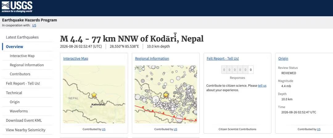
The United States Geological Survey (USGS) measured that a magnitude 4.4 earthquake occurred in Nepal at 10:52 a.m. Beijing Time, with the epicenter located in the upper reaches of the Donglin Tsangpo River where Gyirong Port of Xizang, China is situated. After comprehensive analysis, the USGS updated its conclusion: this tremor was not a tectonic earthquake. The seismic energy was actually generated by a glacial collapse and debris flow.
The official website of the USGS shows that at around 10:52 a.m. Beijing Time on August 26, a magnitude 4.4 earthquake occurred near the China-Nepal border.
Fan Xuanmei, director of the State Key Laboratory of Geohazard Prevention and Geoenvironment Protection at Chengdu University of Technology, told the journalist in the early morning of the 27th that based on current data, this event should be an ice-rock avalanche disaster chain event. The seismic motion generated during the disaster was recorded by thestations.
Zhang Qianggong, head of the Climate and Environmental Risk Unit at the International Centre for Integrated Mountain Development (ICIMOD), said, "I understand that all parties are mobilizing satellite resources to observe the on-site situation, and a clearer conclusion is expected to be available on the morning of August 27."
Nepali scientists have reached a consistent inference. Rijan Bhakta Kayastha, a professor at Kathmandu University and climate researcher, explained in an interview with the media, "current information shows that an ice avalanche on the Nepalese side blocked the Runde River." After the river was blocked, the water level in the upper reaches kept rising, and finally broke through the blockage and poured downstream.
Fan Xuanmei mentioned that the preliminary judgment shows that the main source area of this disaster is located in the northern slope of Langtang Lirung Peak in Nepal.
Fan Xuanmei told the reporter that based on existing evidence, it is preliminarily judged that this event may have gone through a complete disaster chain process: a high-positioned ice-rock mass lost stability and collapsed, moved rapidly after entering the gully, accompanied by ice-water phase change, scoured and carried materials in the gully along the way, and finally evolved into a large-scale mountain torrent and mudslide. Then it moved downstream at high speed along the river valley, passed through Gyirong Port and continued into Nepal, causing severe disasters.
However, Fan Xuanmei stated that this time is different from last year’s disaster at Gyirong Port. The 2025 event was a mountain torrent and mudslide caused by a glacial lake outburst, while the characteristics of this current event correspond well to the process of a high-positioned ice-rock mass collapse.
In recent years, frequent glacial activities in the Himalayas are closely related to glacial melting caused by global climate warming. "Without temperature rise, glaciers are in a frozen state. After climate warming and increased precipitation, rainwater seeps into rocks and the interior of glaciers, exacerbating the instability of glaciers," the aforementioned glacial researcher in Chengdu explained.
On February 7, 2021, an ice-rock avalanche accident also occurred in the Chamoli region of India in the western Himalayas, resulting in more than 200 people missing or dead.
2. Glaciers plunging into rivers and rushing down at high speed
On the morning of August 26, 2026, a glacier on the high-altitude mountain on the Nepali side lost its last stability. The ice mass, together with the rocks it carried, collapsed as a whole and rushed down at high speed along the steep mountain slope.
"The energy generated by a high-positioned ice-rock avalanche is enormous, far more powerful than an ordinary glacial lake outburst," said the aforementioned glacial researcher from the Chengdu research institution. "We have been monitoring the glacial lakes in this region, and they are very stable — they are not the culprit of this disaster." Dr. Yi Shaoliang, an expert from ICIMOD who is permanently based in Nepal, combined speculations from local Nepali experts and public information to conclude that this mudslide was caused by a sudden high-altitude ice-rock avalanche on the Nepali side, rather than a glacial lake outburst.
"The time interval from the occurrence of the ice-rock avalanche to its transformation into mudslide and flood is very short. If a barrier lake had formed first and then an outburst flood occurred, the river would have been blocked and cut off for a period of time. The current seismic motion signal data shows obvious signal characteristics of an ice-rock avalanche-debris flow," Fan Xuanmei said.
However, regardless of whether temporary river blockage occurred or not, the flood transformed from the ice-rock avalanche, carrying sediment, rocks and trees eroded along the way, rushed down at high speed along the steep canyon.
Yi Shaoliang emphasized that due to the terrain, the rivers in this area have a large gradient, "the downward rushing kinetic energy is extremely strong, and the speed gets faster the further downstream it goes." After causing devastating damage to the Gyirong Port area, the flood rushed all the way south along the Bhote Kosi Valley, destroying villages, markets, bridges, hydropower stations and resorts on the Nepali side. The affected area spans more than 200 kilometers, and the impact even extended to downstream areas such as Tading County in Nepal.
3. Backflow that destroyed the port?
When the flood reached Gyirong Port, a special terrain pushed this disaster to its extreme.
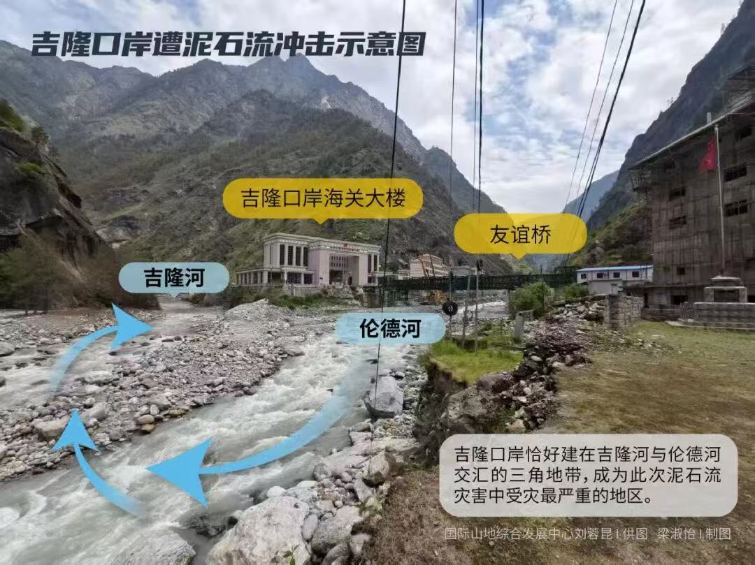
Gyirong Port is precisely built in the triangular zone where the Gyirong Tsangpo River(also known as Gyirong River) and the Runde River meet. Both rivers are China-Nepal boundary rivers, with extremely narrow valleys and steep mountain walls on both sides.
The flood rushed down from the Runde Tsangpo River directly in front of the customs building, and was supposed to continue turning right along the river channel and flow downstream. However, Yi Shaoliang conducted a careful on-site investigation in 2025 and found that the Runde River and the Gyirong River form an almost right angle, and the rock on the right bank of the Gyirong River is "extremely hard, with a very solid mountain body". The flood rushing down from the Runde River most likely hit the hard mountain wall on the opposite side, could not move straight forward, and thus produced a violent backflow.
After being blocked by the mountain body on the right bank of the main river channel, the flood that was supposed to flow downstream along the main channel instead swept towards the port facilities on the Chinese side.
As of the press time, the cause of the disaster is still under further investigation. Multiple interviewees stated that to determine the specific scale and exact location of the ice-rock avalanche, higher-resolution satellite images are still needed.
Translator: Peng Qing
First Review: Zhi Xinghua
Second Review: Li Chengye
Third Review: Hu Rongguo
Copyright © Xizang Daily & China Xizang News All rights reserved
Reproduction in whole or in part without permissions prohibited
Index Code: 藏 ICP 备 05000021 号
Producer: Xizang Daily International Communication Center