





Source:xzxw.com 2026-09-09
Search and rescue operations are continuing in an orderly manner in both China and Nepal following the catastrophic mudslide that struck the border region on August 26. The emergency response headquarters for the "8·26" mudslide disaster in Gyirong County, China’s Xizang Autonomous Region, reported that as of 6:00 p.m. on September 5, the disaster had claimed 43 lives, with 519 people still missing. According to Nepalese authorities on September 7, 1,355 bodies had been recovered in the affected areas of Nepal. “From what we have observed on the ground, this disaster exhibits very clear cross‑border and cascading characteristics,” Li Xin, deputy director of theInstitute of Tibetan Plateau Research of the Chinese Academy of Sciences, told the Global Times. “It is not accurate to say that one side suffered ‘more severely’ than the other. Rather, it is the same transboundary disaster that has manifested in different forms under different terrain and infrastructure conditions.” Several Chinese and Nepalese experts interviewed on September 7 provided detailed analyses of the differing impacts, rescue difficulties, and recommendations for strengthening early warning systems and cooperative response measures. Basanta Raj Adhikari, an expert from Tribhuvan University in Nepal, proposed the establishment of a regional platform called the “Himalayan Monitoring Centre,” with participation from China, Nepal, Pakistan, India, Bhutan, and other countries.
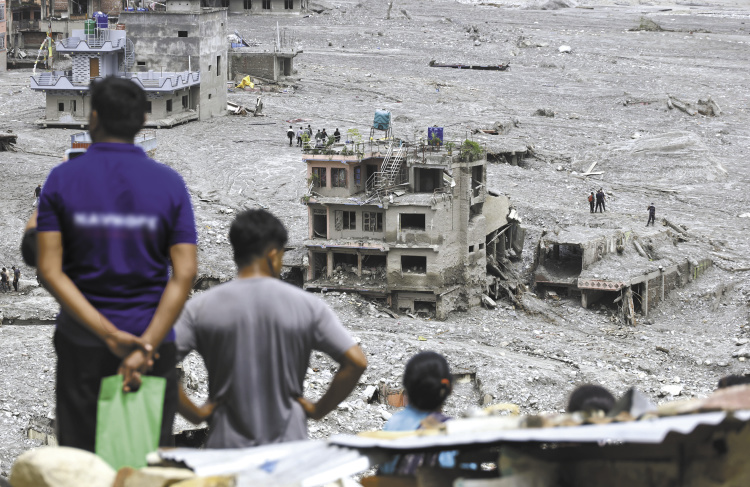
A village in Nepal shows severe building damage caused by the mudslide. [Photo/Visual China]
How do the disasters differ?
On the morning of August 26, a glacier on the northern slope of Langtang Lirung, within Nepalese territory, collapsed at an elevation of about 5,200 meters, triggering an ice‑rock avalanche. The mass rapidly fell to around 4,000 meters, scouring the mountainside and generating a massive debris flow that surged along the Purepu Tsangpo River and Donglin Tsangpo River for about 22 kilometers before reaching China’s Gyirong Port at an altitude of roughly 1,800 meters. The impact flattened approximately 0.7 square kilometers of the port area, destroying 27 buildings and auxiliary facilities, and cutting off roads, communications, and power supplies to the port.
At the T‑shaped confluence of the Gyirong Tsangpo River and Donglin Tsangpo River valleys, the debris‑laden torrent, carrying boulders and sediment, split into two streams by inertia: one surged upstream into the Gyirong Tsangpo River valley on the Chinese side, traveling nearly 3 kilometers along the National Highway G216; the other continued downstream along the Donglin Tsangpo River into Nepal’s lower valleys, extending for tens of kilometers.
“The disaster was initially triggered by a high‑altitude glacial collapse in Nepal. The ice‑rock debris rapidly descended, entraining glacial till, sand, gravel, and boulders, and gradually evolved into a high‑speed debris flow that propagated downstream, severely impacting both sides,” Li Xin told the Global Times on September 7.
Li further noted that the patterns of impact differ. On the Chinese side, the damage is relatively concentrated in the Gyirong Port and adjacent river valley areas, characterized by sudden onset and extremely high impact intensity, with severe destruction of port facilities, roads, communications, and power infrastructure. The port itself lies in a deep mountain gorge, so the disaster delivered a very powerful blow within a confined space. On the Nepalese side, the impact is more regionally distributed along the downstream valleys. Beyond border areas, villages, markets, roads, bridges, and hydropower projects were affected, with search and rescue and infrastructure repair tasks particularly prominent at damaged hydropower stations and tunnels.
Basanta Raj Adhikari, director of the Disaster Research Centre at Tribhuvan University’s School of Engineering, told the Global Times on September 7 that the Chinese side,namely, Gyirong, suffered severe effects concentrated near the source and border crossing areas, “where the initial ice‑rock avalanche and mudslide had very high energy.”
Rasuwa and Nuwakot districts are the worst‑hit areas in Nepal. Adhikari explained that in Rasuwa, the debris flow entered steep, narrow valleys, which allowed it to maintain high velocity and intensify channel erosion, while entraining boulders, sediment, and debris from the riverbed—increasing its volume and destructive power. In Nuwakot, as the valley widens, the flow velocity decreases, but flooding and sediment deposition spread over a larger area, affecting settlements, farmland, and infrastructure.
What are the respective rescue difficulties?
What are the challenges for rescue efforts at Gyirong Port? Mohan Bahadur Chand, a Himalayan glaciologist and assistant professor at Kathmandu University in Nepal, told the Global Times that the narrow river valley and the burial of infrastructure around Gyirong Port make access, excavation, and victim identification extremely difficult. In addition, unstable slopes may trigger secondary hazards.
Adhikari echoed that the destructive energy of the mudslide was concentrated in the steep, narrow Gyirong Valley, and that search and rescue operations are hampered by unstable slopes, thick debris deposits, rockfalls, and limited access to the port area.
After seven days of continuous repairs, the 3‑kilometer rescue access road to the core area of Gyirong Port was largely reopened on September 2. Sources said that the construction site is extremely narrow, preventing large machinery from operating in multiple locations or in a staggered, continuous manner, with insufficient space for equipment deployment and turnaround. “At the most difficult point, progress was less than 5 meters in two hours,” they added.
What are the difficulties on the Nepali side? Chand said that the affected area in Nepal is much larger, “which brings a different set of problems: numerous damaged bridges, roads, settlements, and hydropower facilities spread over tens of kilometers, requiring simultaneous rescue operations, tunnel work, helicopter access to affected zones, and restoration of transport links.”
Adhikari noted that in Rasuwa, steep terrain and damaged roads and bridges may isolate some settlements and hydropower stations, so rescue relies on helicopters, local teams, and other means. In Nuwakot, the wider valley allows floodwaters and debris to spread more broadly, creating a larger search area and more dispersed damage.
Following the disaster, Chinese experts and rescue personnel have been assisting Nepali counterparts in close coordination. According to experts, damage to civilian buildings and engineering facilities along the river in Nepal is severe, and on‑site search operations face numerous challenges.
How can the two countries strengthen early warning and response?
Against the backdrop of global warming, the internal stability of glaciers is decreasing and freeze‑thaw cycles are intensifying. Scientists generally believe that the frequency of ice avalanches may increase in the future. How can China and Nepal enhance early warning and response cooperation?
“Establishing a formal network that directly connects all agencies responsible for disaster management and response is essential,” said Prakash Pokhrel, a geologist at Nepal’s National Disaster Risk Reduction and Management Authority (NDRRMA), on September 7. To mitigate growing risks, the NDRRMA is planning to build a comprehensive early warning system with sensor installations in disaster‑prone areas.
“Nepal and China should set up a real‑time cross‑border high‑mountain disaster monitoring and data‑sharing system, which should include satellite and drone monitoring, seismic and ground‑based sensors, glacier lake and river level monitoring, and automatic detection of major ice‑rock instabilities,” Chand told the Global Times. The two countries should promptly transmit cross‑border alerts and conduct regular joint emergency drills.
“It is especially important that the warning system can cover rapid ‘cascading hazards’ that develop within minutes,” Chand added. A cascading hazard refers to a chain of interconnected events triggered by an initial disaster, amplifying impacts progressively.
Adhikari proposed the establishment of a regional “Himalayan Monitoring Centre” involving China, Nepal, India, Bhutan, Pakistan, and others. The centre would use seismic sensors, satellites, GNSS, and hydro‑meteorological networks to jointly monitor glaciers, unstable slopes, high‑altitude lakes, and river systems. “The centre should enable real‑time cross‑border data sharing, unified risk thresholds, and rapid alert mechanisms, so that ice‑rock avalanches and cascading floods can be detected at their source by all countries, allowing evacuations and emergency responses to be activated before destructive mudslide reach downstream communities,” he said.
Su Pengcheng, a researcher at the Institute of Mountain Hazards and Environment, Chinese Academy of Sciences, stated at a press conference on September 6 that, given the actual conditions at Gyirong Port, future efforts should focus on: first, strengthening research on the disaster formation mechanisms of transboundary ice-rock avalanche–debris flow cascades in the Himalayan region,and improving early identification of warning signals; second, establishing a space‑air‑ground integrated non‑contact monitoring system across the Himalayan region to reduce reliance on ground stations in extremely high‑altitude source areas; and third, promoting cross‑border scientific cooperation and synchronized early warning mechanisms.
“China and Nepal need to strengthen joint transboundary basin hazard investigation, assessment, monitoring, and early warning, and establish information‑sharing mechanisms,” said Kang Shichang, director of the Institute of Mountain Hazards and Environment, on September 7.
Li Xin added that, in terms of data cooperation and sharing, China and Nepal have long collaborated, starting with early glacier and glacial lake inventories in the Himalayas. “In recent years, the National Tibetan Plateau Data Center and the International Centre for Integrated Mountain Development (ICIMOD), based in Kathmandu, have carried out data sharing and interoperability for the ICIMOD regional database. In future disaster response, more rapid and comprehensive data sharing would greatly benefit disaster prevention and mitigation.” Regarding monitoring, Li said: “In addition to building joint monitoring systems, the two sides should also establish a cross‑border drone flight mechanism. Drones are a very important tool for rapid disaster response.”
Reporters: Chen Zishuai, Shen Sheng
Translators: Yeshi Tsomo, Zheng Yujie
First Reviewer: Zhi Xinghua
Second Reviewer: Drakpa Wangchen
Third Reviewer: Hu Rongguo
Copyright © Xizang Daily & China Xizang News All rights reserved
Reproduction in whole or in part without permissions prohibited
Index Code: 藏 ICP 备 05000021 号
Producer: Xizang Daily International Communication Center